


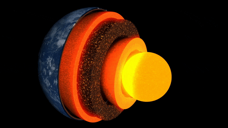
الرسوم المتحركة لطبقات الأرض.
حصل بحث جديد بقيادة جامعة كامبريدج للمرة الأولى على “صورة” مفصلة لجيب غير عادي في الطبقة الحدودية على بعد حوالي ثلاثة آلاف كيلومتر تحت السطح ، مع مركز الأرض.
المنطقة الغامضة من الصخر أسفل جزر هاواي مباشرة هي واحدة من العديد من المناطق عالية السرعة – والمعروفة بموجاتها البطيئة الزاحفة حيث تمر الموجات الزلزالية من خلالها.
نُشر البحث في عدد من المجلة بتاريخ 19 مايو 2022 الاتصال الطبيعيكشفت أولاً عن التباين الداخلي المعقد لأحد هذه الجيوب ، والذي يلقي الضوء على تضاريس باطن الأرض والعمليات التي تعمل داخلها.
“من بين كل الأجزاء الداخلية العميقة للأرض ، هذه هي الأكثر جاذبية وتعقيدًا.” – زي لي
قال جي لي ، طالب دكتوراه ، “من بين جميع الأجزاء الداخلية العميقة للأرض ، هذه هي الأكثر روعة وتعقيدًا. لدينا الآن أول دليل قاطع لإظهار هيكلها الداخلي – وهذا معلم حقيقي في علم الزلازل العميقة”. كاتب في قسم علوم الأرض في كامبريدج.
باطن الأرض مكدسة مثل البصل: في الوسط يوجد قلب من الحديد والنيكل ، محاط بطبقة سميكة من الوشاح ، مع قشرة خارجية رقيقة – القشرة التي نعيش عليها. على الرغم من أن الوشاح عبارة عن صخور صلبة ، إلا أنه ساخن بدرجة كافية بحيث يتدفق ببطء شديد. تقوم التيارات الحرارية الداخلية بتسخين السطح ، وتوجيه حركة الصفائح التكتونية وتسبب الانفجارات البركانية.
يستخدم العلماء الموجات الزلزالية من الزلازل “لرؤية” ما تحت سطح الأرض – يصدر أصداء وظلال هذه الموجات صورًا تشبه الرادار للداخل العميق. ولكن حتى وقت قريب ، كانت “صور” الهياكل الموجودة على حدود الوسط-ماندالا والتي كانت محل الاهتمام الرئيسي في استكشاف تدفق الحرارة الداخلي لكوكبنا حبيبية ويصعب تفسيرها.
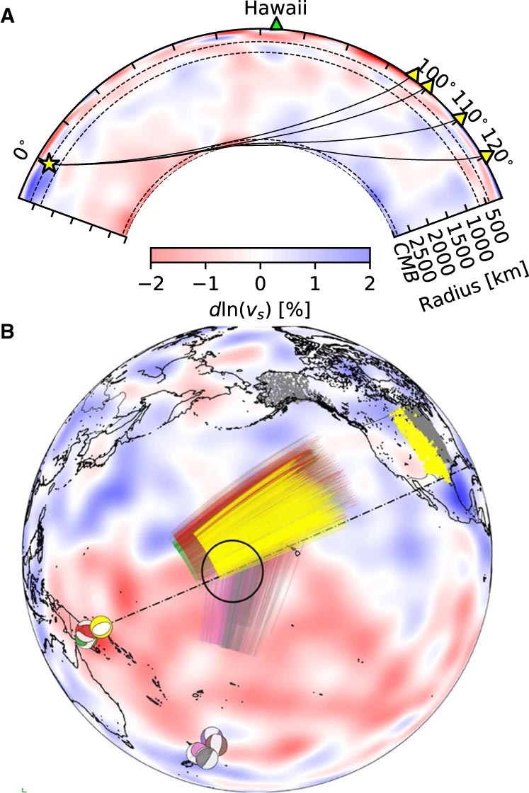
الأحداث المستخدمة في هذه الدراسة ومسارات إشعاع Sdiff. أ) المقطع العرضي لمركز منطقة هاواي فائقة السرعة المنخفضة يوضح مسارات الإشعاع لموجات Sdiff عند 96 درجة و 100 درجة و 110 درجة و 120 لنموذج أرضي أحادي الأبعاد PREM. تمثل الخطوط المرسومة من أعلى إلى أسفل 410 كيلومترات و 660 كيلومترًا من التعليق و 2791 كيلومترًا (100 كيلومتر فوق حد الوشاح الأساسي). ب) الأحداث ومسارات الإشعاع Sdiff في عينة التصوير المقطعي الخلفية SEMUCB_WM1 على عمق 2791 كم. معظم كرات الشاطئ المستخدمة في هذه الدراسة كانت أحداثًا مخططة بألوان مختلفة بما في ذلك 20100320 (أصفر) ، 20111214 (أخضر) ، 20120417 (أحمر) ، 20180910 (بنفسجي) ، 20180518 (بني) ، 20181030 (وردي) ، محطة 20161 (20161) محطة) (20161) مسارات موجات الصدف على عمق 2791 كم في الوشاح السفلي. يتم تمييز الحدث المستخدم في التحليل قصير المدى باللون الأصفر. يظهر موقع ULVZ المقترح في دائرة سوداء. يُظهر الخط المتقطع التقاطع المخطط له عند A. الائتمان: Nature Communications ، DOI: 10.1038 / s41467-022-30502-5
استخدم الباحثون أحدث طرق نمذجة الأرقام للكشف عن الهياكل التي يبلغ عرضها كيلومترًا واحدًا على حدود الوشاح الأساسي. وفقًا للمؤلف المشارك الدكتور جوانجداي لينج ، فقد طور هذه الأساليب[{” attribute=””>University of Oxford, “We are really pushing the limits of modern high-performance computing for elastodynamic simulations, taking advantage of wave symmetries unnoticed or unused before.” Leng, who is currently based at the Science and Technology Facilities Council, says that this means they can improve the resolution of the images by an order of magnitude compared to previous work.
The researchers observed a 40% reduction in the speed of seismic waves traveling at the base of the ultra-low velocity zone beneath Hawaii. This supports existing proposals that the zone contains much more iron than the surrounding rocks – meaning it is denser and more sluggish. “It’s possible that this iron-rich material is a remnant of ancient rocks from Earth’s early history or even that iron might be leaking from the core by an unknown means,” said project lead Dr Sanne Cottaar from Cambridge Earth Sciences.

Conceptual cartoons of the Hawaiian ultra-low velocity zone (ULVZ) structure. A) ULVZ on the core–mantle boundary at the base of the Hawaiian plume (height is not to scale). B) a zoom in of the modeled ULVZ structure, showing interpreted trapped postcursor waves (note that the waves analyzed have horizontal displacement). Credit: Nature Communications, DOI: 10.1038/s41467-022-30502-5
The research could also help scientists understand what sits beneath and gives rise to volcanic chains like the Hawaiian Islands. Scientists have started to notice a correlation between the location of the descriptively-named hotspot volcanoes, which include Hawaii and Iceland, and the ultra-low velocity zones at the base of the mantle. The origin of hotspot volcanoes has been debated, but the most popular theory suggests that plume-like structures bring hot mantle material all the way from the core-mantle boundary to the surface.
With images of the ultra-low velocity zone beneath Hawaii now in hand, the team can also gather rare physical evidence from what is likely the root of the plume feeding Hawaii. Their observation of dense, iron-rich rock beneath Hawaii would support surface observations. “Basalts erupting from Hawaii have anomalous isotope signatures which could either point to either an early-Earth origin or core leaking, it means some of this dense material piled up at the base must be dragged to the surface,” said Cottaar.
More of the core-mantle boundary now needs to be imaged to understand if all surface hotspots have a pocket of dense material at the base. Where and how the core-mantle boundary can be targeted does depend on where earthquakes occur, and where seismometers are installed to record the waves.
The team’s observations add to a growing body of evidence that Earth’s deep interior is just as variable as its surface. “These low-velocity zones are one of the most intricate features we see at extreme depths – if we expand our search, we are likely to see ever-increasing levels of complexity, both structural and chemical, at the core-mantle boundary,” said Li.
They now plan to apply their techniques to enhance the resolution of imaging of other pockets at the core-mantle boundary, as well as mapping new zones. Eventually, they hope to map the geological landscape across the core-mantle boundary and understand its relationship with the dynamics and evolutionary history of our planet.
Reference: “Kilometer-scale structure on the core–mantle boundary near Hawaii” by Zhi Li, Kuangdai Leng, Jennifer Jenkins and Sanne Cottaar, 19 May 2022, Nature Communications.
DOI: 10.1038/s41467-022-30502-5

“متعصب للموسيقى. مستكشف متواضع جدا. محلل. متعصب للسفر. مدرس تلفزيوني متطرف. لاعب.”
More Stories
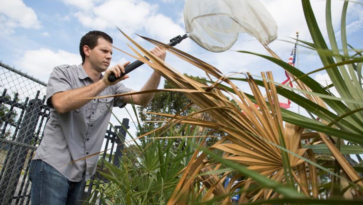
يأمل علماء UF في إيقاف مرض البرونز القاتل في أشجار النخيل في فلوريدا
“الذكاء الاصطناعي يساعدني في صنع النبيذ للشاربين الصغار”
مهمة Starlink من KSC مساء الأربعاء